Showing posts sorted by relevance for query plymouth. Sort by date Show all posts

11 October 2013

A Post in Defense of Plymouth, or a Response to Ostrander

Plymouth's most glorious main street bridging the Wythougan and leading into its Downtown

Recently I was made aware of a rather uncomplimentary blog post regarding one of Indiana's most unique little crossroads cities, Plymouth.  More specifically, the blogger compared the picturesque town's supposed shortfalls with its neighbor to the east, Warsaw.  The Ostrander blog post is here if you find it necessary to read his defenseless (and rather silly, exaggerated) scorn of Plymouth whilst heaping undue accolades upon his beloved Warsaw.

Indeed I suspect that Ostrander is a native of the wannabe Kokomo on U.S. 30, and likely participated in sport at its school, that looks like a prison, where his disdain really stems from the age-long rivalry between the cities.  To the contrary, I am not a native of Plymouth but am quite familiar with the city.  The charming town of Plymouth was situated on a river dubbed "Wythougan" by the Native American, at the crossing of Indiana's most historic and important road, the Michigan Road.  Early residents named the budding village in honor of the settlement our Puritan forefathers, who sailed but with their faith, staked out that would become the foundation of a new nation.

No, indeed, Plymouth's streets are not paved with gold either.  But they are shaded by the most magnificent trees that define the main street as, in the words of university professors, the most impressive thoroughfare in all of Northern Indiana, Warsaw included.  And at this time of year the main street is illuminated in gold from its living sentries stationed along its sidewalks.  Added to the charm of this main street is its historic streetlights that sparkle like diamonds as you stroll the broad sidewalks at night.  And what can Warsaw say to this?  Within months Plymouth will boast its main street as the longest contiguous corridor on the National Register of Historic Places in Indiana, save Meridian Street in Indianapolis.

I cannot even determine where Warsaw stops and starts as the stoplights keep reproducing.

Furthermore, Plymouth-while bypassed not once, but twice, maintains one of the most attractive downtowns in Northern Indiana.  The city embraces its unique place in not only history, but in geography, as a crossroads of important routes now designated by the State of Indiana as State Scenic Byways.  Warsaw can boast only stop-and-go traffic on U.S. 30 and a convoluted street grid that defies even the most astute of minds.  Plymouth's parks are strung around the city like precious gems in a necklace, the most important of which is underway in the city's downtown.  Warsaw has a park, well removed from the city, that is used as a refuge for those wishing to escape the city's tired and worn neighborhoods.  Warsaw turned its back on its best God-given feature, a lake, and chose to pollute it instead.

The Ostrander blog post pictured an ominous backdrop to the county courthouse situated in Plymouth.  Unlike Warsaw's founders, Plymouth's early residents determined that the seat of government should be in the midst of the people because the government is elected by and for the people.  This location amid neighborhoods is one of only two such placements in the entire state.  Warsonians determined that their government should be under the close scrutiny and control of its bankers, lawyers, and merchant-tycoons.  Not the people.

So let us talk about Plymouth's people.....true salt of the earth people.  Plymouthites are those who roll up their sleeves and get to work, unlike the neighboring Warsonians who sit and wait for one of their medical industries to gift them something.  Plymouth people are more than generous, in fact, one day nearly a year ago, is being heralded as one of the biggest days of benevolence ever seen in Indiana where hundreds participated in a single day of giving that resulted in over a half-million dollars raised for the community......whilst Warsaw waits for more handouts.

And yes, Plymouth's mayor's head is bald, as Ostrander pointed out, but it is well-polished, like so many of the city's fine residences.  And unlike Warsaw's meager coffers, Plymouth-through the leadership of its state-recognized clerk-treasurer-has amassed wealth that would make a city ten times Plymouth's size green with envy.


Warsaw's answer to both industry and culture
Ostrander implied that Warsaw's many more chain stores confirmed the city's better standing.  As I read, I thought he had decided to compliment Plymouth, because how indeed are more greasy french fries a sign of economic vitality?  I applaud Plymouth's lack of chains that pump dollars out of the community.  For culture Warsonians have fled to their sister city, Winona Lake.  Again, Plymouthites roll up their sleeves to produce for themselves rather than sit back and feel entitled to be entertained.  The proof is in the Midwest's largest three day festival held, no, not in Warsaw, but in Plymouth.

For all that Plymouth may lack, this is certain, its residents do not lack hearts of gold, the hearts of champions, and the steely-grit and determination to never become like Warsaw.

Actually, Warsaw's not all that bad......the post is just in keeping with the tenor of the Ostrander post.

03 January 2020

The LaPorte & Goshen Roads' History


With the closure of the intersection of Plymouth-Goshen Road at U.S. 30, I thought it would be good to look back at the history of this road most of us probably are not aware of....and with it the parallel history of the Plymouth-LaPorte Trail.  Only the Michigan Road through Marshall County claims an older history as an established road.  I think sometimes it's hard for us to not think we're the center of the universe, here at the crossroads, but I'll take you back before there was a Plymouth.

Imagine most of  Northern Indiana, north of Logansport to the south edge of the St. Joseph River Valley, was largely unsettled in the 1820s-early 1830s.  A few posts existed in Michigan City (due to the Michigan Road), LaPorte, South Bend, and by the early '30s, Goshen.  This great middle part of Northern Indiana between the Wabash River (canal) and St. Joe River lacked roadways which is why the Michigan Road became so important to the settlement of the state.  To understand the development of the LaPorte and Goshen Roads, you'd have to understand the Michigan Road's history.  Surveyed in 1829, the road connected Madison to Michigan City (established as a port at the northern terminus).  Construction of the road began in 1830 and by 1836 it was mostly complete (passable).  Plymouth was founded in 1836 by three men, one of whom was the chief superintendent of construction on the road-Mr. William Polke.  The road was originally conceived to go north from Logansport to LaPorte, but surveyors felt that the Kankakee Marsh proved too difficult to build through, so it doglegged and went northeast, then straight north toward South Bend.  Both Rochester and Plymouth followed the road.

Prior to Plymouth being established, both LaPorte and Goshen were interested in the construction of the Michigan Road as it came north from Indianapolis.  The Michigan Road brought trade and postal carriers, but more importantly, settlers to the region.  Because of the road's crossing of the Yellow River in what would become Plymouth, both Elkhart and LaPorte County Commissioners felt there was a need to tap into the Michigan Road at that point.  LaPorte County was first to do so.  In 1833, the LaPorte County Commissioners paid for the establishment of the "Yellow River Road" to go southeasterly out of LaPorte toward a crossing of the Kankakee River where a ferry was authorized.  The road also extended northwest from LaPorte to tap into the Michigan Road leading from South Bend to Michigan City.  A bridge over the Kankakee followed shortly after, and the road was planked by the 1840s.  According to Daniel's History of LaPorte County "the road and ferry did much to advance the county in population, as it made Michigan City the market for all the country as far south as Logansport."

Today, this route is part of the state highway system in LaPorte and St. Joseph Counties, but not in Marshall County.  State highway designations are U.S. 35 from its intersection with the Michigan Road (U.S. 20) south to LaPorte, then State Road 4 southeast of LaPorte until 4 turns toward North Liberty-the old trail follows State Road 104 to the west edge of Walkerton (which was not established until the early 1870s).  With some diligence, one can make out segments of the old Yellow River Road, which took on the name "Plymouth-LaPorte Trail" through the southwest corner of Walkerton, then into Marshall County.  While the route succumbed to some straightening on section lines, the old trail can mostly be followed to Plymouth where it enters from the west and becomes LaPorte Street ending just a half-block north of the Yellow River Bridge on Michigan Road.  While not evidenced as much in Marshall County, in LaPorte County the old trail features some of the oldest architecture in Northwest Indiana, including the Major Lemon House, built in 1837 at the crossing of the Kankakee.

The Plymouth-Goshen Trail has a similar history.  Elkhart County Commissioners set to building "highways" a term that literally means "roadways built on high ground" shortly after the county was organized in 1830.  The years 1831-32 saw considerable road building.  But, according to a news article, what became known as the Plymouth Trail was established on October 19, 1835.  The desire of Elkhart County Commissioners would have mirrored those of LaPorte's, to open up a direct route, at its shortest point, to the Michigan Road for settlers, commerce, and postal carriers.  Tapping into the route on the north bank of the Yellow River made the most sense, so the Plymouth-Goshen Trail stayed north of the river, only crossing it at its narrow fork width near what would become Bremen, then meandering southwesterly until it joined the Michigan Road about a mile north of the Yellow River Bridge.  The situation with this route, however, was a little different within the  boundaries of Marshall County because of Bremen being established within ten years of Plymouth, along this route.  That meant that a good trade route between the county's two largest villages was secured.

Again, much like the LaPorte Trail, the Goshen Road follows a southwesterly route from Goshen ignoring cardinal points of a grid, much less section lines.  The trail is intact, for the most part, with its current designation of State Road 119 between Goshen and State Road 19.  However, it suffered from rerouting onto designated county roads as well.  The Plymouth-Goshen Trail is fairly obvious in the northeast corner of Marshall County, and from its intersection with State Road 106 west of Bremen to King Road where it follows about two miles directly south before it cuts off to the southwest again north of King Road's Yellow River Bridge.  Older maps would likely give a better idea of the route before it was conformed to the grid.  The State of Indiana felt that the old route was important enough still to maintain it as an overpass for the new U.S. 31 northeast of Plymouth, however, with the number of accidents occurring now at its intersection with U.S. 30, the road was cut off.  I recall a vote while on the Plymouth Plan Commission when the state asked us which intersection was the most important to address for safety (in about 2005), and we indicated U.S. 30 and Plymouth-Goshen.  And since that time, they've improved three other intersections on 30, but not the one we requested.

If you imagine Plymouth, as a county seat, being connected to all of its neighboring county seats and mostly larger population centers, due to these roads, we should have had greater prosperity.  We had direct routes, the best of their time, to Goshen, South Bend, LaPorte/Michigan City, and Rochester/Logansport.  When the Yellowstone Trail was established in the early 1900s, we were also connected to Warsaw/Ft. Wayne and Valparaiso/Chicago.  I did wonder, though, why the routes in Marshall County were never designated state routes when they were in LaPorte and Elkhart Counties.  So, I did a little investigation that yielded only a little information.  Evidently, when the state highway commission began in earnest designating state routes, Highway 17 had been proposed between Logansport and Goshen, following its current route from Logansport to Plymouth, but then following the Plymouth-Goshen Trail for its last leg.  This was being promoted, particularly by Bremen, as early as 1929 (photo above).  Why it never occurred, and why only the portion of 119 was designated (by 1940), is a mystery to me.  Marshall County was left out.  The Plymouth-LaPorte Trail's lack of designation in Marshall County is also strange.  During the early 1930s, the old trail was considered an "improved" county road in all three counties it touched, however, Marshall County's segment was of a lower quality construction.  This remained true in 1940, though in all counties, the construction improved.  But by 1945, both State Roads 4 (between LaPorte and North Liberty) and 104 (south to Walkerton) had been designated.  It remained a county road south of Walkerton. This may have been in part to the development of the Kingsbury Ordnance Plant during WWII, just west of these routes in LaPorte County.  Left out again.  Did the lack of designations in the 1930s-40s have an economic impact on Marshall County?  It's hard to say.  Being the crossroads doesn't necessarily put you at the center of the universe, even as we sit here now at the crossing of two of Northern Indiana's most important highways: 30 & 31.

03 February 2014

How Studebaker's reach shaped Plymouth's railroads

The new Pennsylvania Depot in Plymouth created after the railroad's acquisition of the Vandalia line
I'm knee deep in Studebaker history right now, but with a very targeted perspective of Studebaker's influence on the railroads.  I've been handed a task to justify inclusion of the two depots that lie adjacent to the former Studebaker manufacturing campus in a combined historic district.  The challenge:  prove that the depots are there because of Studebaker.  It seemed more difficult than it proved.
The Vandalia Depot on South Main Street, South Bend, c. 1910.  Studebaker's warehouse is on the right side of the photo in the background.

In the early 1880s the Studebaker brothers, along with other prominent members of South Bend, began pushing for a rail alignment to open markets in the south.  Up until this time, industry was connected to points east and west, but without direct links to the south.  So to help move the project along, a corporation was formed, with Studebaker Bros. Manufacturing being the leading stockholder, that purchased right-of-way south from South Bend through Plymouth into Logansport and points further south. Their intention was not to personally build and operate the rail, but provide the easement on which a railroad could be constructed on the route the South Bend industrialists desired.  The process moved a little slower than they had hoped, but eventually a railroad company was landed and the line became known as the Vandalia Railroad.  Where was the northern terminus of the railroad?  Immediately adjacent to the Studebaker warehouse between Main and Lafayette Streets, and immediately south of their administration building.

Later the Vandalia line was leased to the Pennsylvania Railroad which crossed the Vandalia in Plymouth.  This became an extremely important hub for the Studebakers because it provided both the southern route they desired, but also permitted another east/west route to large markets yet untouched.  It should be no surprise then, shortly after the Pennsylvania Railroad leased the Vandalia line, that a new depot station was constructed in Plymouth and their crossing even though the older Vandalia Depot in Plymouth remained.

This photo of the Nickel Plate Depot in Plymouth was taken probably the last time the building was painted, which looks to be the early 1970s.  The building is on Garro Street just west of the downtown.
But the Studebaker Corporation didn't focus their influence with just the Vandalia and Pennsy.  Clement Studebaker, the founder, shamed the Lake Shore and Michigan Railroad into building a new depot to replace an old wooden one already sandwiched between the company's expanding campus.  When Albert Erskine, who took over the Studebaker Corporation, made a speech to South Bend businessmen in 1919, he rolled out an impressive vision for Studebaker that would result in adding over 3 million square feet to their manufacturing facilities.  The primary one being the large building that forms a backdrop to Coveleski Stadium and Union Station.  In Erskine's speech, he implored the railroads to aid in the development of Studebaker by elevating the tracks, combining the Grand Trunk with the New York Central, and to build a new station.  And his words carried a great deal of weight since Studebaker was the 4th largest auto manufacturer at that time.  By the mid-to-late 1920s the tracks had been elevated and Union Station, rivaling other depots in cities many times the size of South Bend, was constructed.

Union Station and the Vandalia Depot still exist in South Bend and have found important new uses.  The situation in Plymouth isn't as bright for the city's remaining depots.  The Vandalia Depot was demolished in the early 1990s, despite having been a stop for presidential candidates and future presidents.  The Pennsylvania Depot that was built to accommodate the company's acquisition of the Vandalia line, sits vacant and deteriorating, but retains some vestige of its more elaborate past.  Plymouth has one other depot that remains, albeit in a state of abuse and neglect.  The Nickel Plate depot has seen its better days as well.  Both the Pennsy and Nickel Plate Depots should be preserved-the difficulty is in getting a railroad completely uninterested in community development or pride, to agree.

21 February 2012

Plymouth main street Part 5


The Cleveland House (on left above) was constructed in the Craftsman style applied to an American Four-Square plan in about 1915. Charles and Mary Lamson Cleveland came to Plymouth with their only child, Arnott, in 1891. They previously had lived at Edgerton, Ohio. Cleveland founded the Edgerton Manufacturing Company in Plymouth in 1891. The company became the largest producer of basket and fruit packaging products in the United States. Cleveland was elected mayor of Plymouth in 1910 at which time he turned over control of the company to his son. By 1920 Charles returned as an assistant manager of the factory. Mary continued to live at the residence after her husband’s death into the 1930s.

The Miller House (on right above) was constructed in 1911 in the Free Classic style. William Foker, renowned stone mason from Argos, was responsible for the porch and foundation. Welcome J. and Clara Heyde Miller had this home constructed for them in 1911. They lived here with their daughter, Virginia, who was born in 1909. Welcome was a piano tuner and salesman in the county. He was tragically killed at a railroad crossing in Plymouth in 1942. Clara continued to live at the home into the 1950s.


The Cullison House was designed in a unique Plymouth blend of the Free-Classic and Craftsman styles. The home was constructed for the Frank and Eveline Cullison family in about 1908. The Cullisons moved to Plymouth from a nearby farm in 1900 to begin a business in the manufacturing of wagon wheels. The business evolved to the manufacturing of buggies at which time it became known as the Plymouth Wagon Works, located on East LaPorte Street in the downtown. The business continued to grow and became known as the Plymouth Body Works which manufactured truck bodies used throughout the United States. The Cullisons raised three sons at the home: Darrel, Floyd, and Oscar. In 1930 they moved to a cottage at Pretty Lake and shortly after the business failed during the Great Depression.

25 February 2012

Plymouth main street Part 7


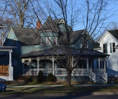
The home on the left was constructed for Frederick and Lucinda Hill in about 1889 in the Queen Anne style. Hill was the proprietor of W. W. Hill & Son, Bakers and Confectioners. Frederick was the son of William W. Hill, who began the bakery in downtown Plymouth in 1855. Frederick was born in Plymouth in 1857. He was the manager of the Central Union Telephone Company in Danville, Illinois until his association with his father’s bakery. Frederick Hill constructed a downtown business block for the bakery; it has a second and third story meeting hall used by the Knights of Pythias, of which he was a member. The building currently houses the Historic Crossroads Center of the Marshall County Museum. The house was recorded in Wilbur Peat’s book Indiana Houses of the Nineteenth Century. Peat describes the house as Neo-Jacobean and states “so massive a roof on a story and a half house gives the impression the walls are struggling to support excessive weight.” At the time the book was written the house was owned by Harvey Phillips.

The Stevens Home was constructed in 1895 in a blend of the Queen Anne and Shingle styles (above-middle). Smith (S. N.) and Martha Martin Stevens and their children Katherine and George F. had this home constructed for them in 1895. Smith and Martha were married in 1893. Smith came to Plymouth from Argos, Indiana in 1884 after receiving an education from Valparaiso University. He was admitted to the bar and began to practice law that same year. He was the Marshall County prosecuting attorney from 1890-1894 and 1897-1904. He was a member of the Plymouth School Board from 1900-1906. He held the office of Democratic County Chairman, Chairman of the 13th Congressional District, and member of the Democratic State Central Committee. Smith Stevens was the attorney for the State Bank of Plymouth as well as the local representing attorney for three railroads in the city. In 1914 he was elected Judge of the Judicial Court Circuit; he held that office until 1920. He practiced law afterward until his death in 1930. His wife, Martha, continued to reside at the home into the 1950s.


Dr. Thomas and Gertrude Eley and their son Thomas Jr. had this home constructed for them in 1935 in the Colonial Revival style. It is one of the newest homes on Michigan Street. The Pilot News carried an article on the home when it was constructed. It was called a FHA Model Home in the article. Dr. Eley was a medical doctor and surgeon. They lived at 825 N. Michigan in 1930 prior to building this home. Dr. Eley was the secretary of the Plymouth Kiwanis Club when it formed in 1921. Mrs. Eley was a founding member of the Plymouth Tri Kappa in 1946. Mrs. Eley continued to live in the home after her husband’s death. She lived in the home she called the “Candlelight House” into the 1950s.


Who hasn't enjoyed this little cottage? It was constructed in about 1895 in the Queen Anne style. Joseph and Alice Anderson are listed at this address in the 1910 and 1920 censuses. Joseph’s occupation in 1910 was listed under commercial trade “brewery” and in 1920 as a manufacturer of cigars at home.

11 March 2012

Indiana Novelty Manufacturing Company: the oldest link to Plymouth's industrial past is gone

Bird's eye view of the Indiana Novelty Manufacturing Company (c. 1898)


I was spending a quiet afternoon at the home of an accomplished architect in Beverly Shores Saturday when phone calls started streaming into our home regarding an enormous fire that was raging in one of Plymouth's largest landmarks. The smoke could be seen in neighboring towns. This morning the hulk of a building was still smoldering, but it was indeed gone.


A later photo (c. 1915) when the building was used by the Abrasive Manufacturing Co.


Plymouth's oldest link to our industrial past was quickly engulfed in flames Saturday afternoon. The building had been recently used for storage and to most Plymouthites is no doubt known by any number of names, however, as a memoriam, I'd like to reflect on its grand beginnings.


The Indiana Novelty Manufacturing Company was organized in 1891 by several leading Plymouth businessmen. Among them were H. G. Thayer (owner of the Thayer mansion), James Gilmore, George Marble, and C. L. Morris (who owned the Morris house kitty-corner from the factory). The company manufactured wooden novelties and was particularly known for wooden bicycle rims and mud and chain guards for bicycles. The company was also the first to invent and market "the famous one-piece interlocking joint, which is excelled by none and which has made the Plymouth rim famous throughout the world." In 1898 the plant was the largest of its kind in the world and at full capacity was producing 10,000 rims PER DAY (in the 1890s!).


The company had sales houses in "every principle city" of the United States and marketed the rims to foreign countries as well. It was estimated that Indiana Novelty was producing more than half of the rims used by cycle makers in the 1890s. The firm employed over 300 hands (whether that means 150 men at 2 hands each, I don't know!) and had a company payroll of $8,000 per month. The company was unrivaled in Marshall County and much of this part of rural Indiana for its size.


The company's own dedicated fire department building
At a bicycle exhibition in about 1895 this was said of the company "the exhibit of the Indiana Novelty Manufacturing Company consisted of a full line of the well known Plymouth wood rims for American or English makes of tires as well as a complete line of handle bars and guards" (from Sporting Life magazine, Jan. 30). The firm was likely at its financial height when the owners sold the company to American Bicycle Company Inc., which was better known as the Bicycle Trust. The Trust was incorporated in June, 1899, and had $40 million in capital. It secured control of 44 plants nation-wide, including two others in Indianapolis (New York Times, Sept. 1, 1899).


The original two story portion of the plant (right side above) housed the company offices. The board room/manager's office had the most remarkable wood coffered ceilings I think I have ever seen. The plant was outfitted with its own fire department building in the southeast corner of the plant. As subsequent owners and manufacturers used the facility, additions were made to the north of the original building and to the south of the original manufacturing line, connecting the once stand-alone fire department building to the rest of the facility. Had the small brick fire department building still been isolated, it may have survived.

Thayer Mansion, Plymouth

The building, which at one time had put Plymouth on the world map, has now moved into our past. Pictures of the fire are here: http://am1050.com/2012/fire-destroys-400-pennsylvania-avenue/

12 September 2008

Historic Bridges of Plymouth

A few years back my involvement in some downtown redevelopment work in Plymouth led me to an interesting discovery. Plymouth has several historic bridges....kinda like Madison County. While you might not think of Plymouth as a river town, the Yellow River, or "Wythougan" in Native American tongue-meaning "yellow waters", meanders through the little city of 10,000.

It wasn't until I went on a canoe trip down the Yellow that I truly realized the coolness of the concrete arched bridges........so here we go......pretend you're on a float trip, feet hanging over the side.......down the river and enjoy.
The first bridge (from north to south, with the flow) is the Jefferson Street/Lincoln Highway Bridge. The double span, filled concrete arched bridge was constructed in 1927 once the final route was chosen for the new Lincoln Highway alignment through Marshall County/Plymouth. While renovations in the 1980's widened the deck and changed the handrails to standard highway design, the historic superstructure is still in place and is begging for restoration.


The next bridge is the Garro Street Bridge. Constructed about 1920, it also is a double span, filled concrete arched bridge but is unusual because of its angle across the river. The original concrete railings still exist on this bridge, as no renovation work was ever made, except to remove some remarkable metal light fixtures at the four corners. I believe refurbishment is in the near future....let's hope the lights come back.

The third bridge is the National Register listed LaPorte Street Footbridge. Constructed in 1898 and fabricated by the Rochester (Indiana) Bridge Company, this bridge is a metal cantilever structure with piers at the banks. Only one other bridge like this exists in the state, in Winamac. I also happened to have proposed to my wife on this bridge.......


Luten Bridge, ca. 1918

Luten Bridge, prior to restoration


The fourth bridge was constructed between 1916-1917 and has the distinction of being a Daniel Luten concrete bridge. Luten was an engineering professor in Indiana who patented his concrete bridge designs that quickly made him famous across the country. The Luten Bridge is the Michigan Street bridge and was constructed in place of the early metal Michigan Road bridge, probably in keeping with the construction of the Yellowstone Trail following the alignment and bringing additional vehicular traffic across the bridge. This bridge was renovated in the 1970's. widening the deck and removing the historic handrails. This year the bridge was restored with handrails sympathetic to the original design being installed, along with the new addition of light fixtures.


The fifth bridge to cross the Yellow River is the Pennsylvania Railroad Bridge produced by the American Bridge Company of New York in 1902. This may be my favorite. The massive steel bridge is one of the earliest Pratt pony style truss designed bridges in Indiana. It is set on massive limestone abutments and is a marvel to walk under along the bank of the river.


Another noteworthy bridge is the Pennsylvania Railroad/Michigan Street viaduct constructed about 1900. This is one of the more identifiable Plymouth landmarks. The steel pony plate girder truss style bridge crosses Michigan Street just south of the Yellow River and rests on massive limestone abutments and center pier. A train once derailed at this location sending rail cars over the north side of the rail to the street below. What would become known as the Pennsylvania Railroad was constructed through Plymouth in 1856. Two other 1900 pony plate girder truss bridges are also located in Plymouth along this rail line. So if you're keeping track-that's 8 historic bridges....not bad for a little town.

25 February 2012

Plymouth main street Part 8


The Corbin-Bechaka House was constructed in about 1865 and designed in the "cube" Italianate style. The home’s architecture developed with successive owners of the house. Horace Corbin had the home constructed in about 1865. At the time it was constructed Corbin owned the entire block on the west side of Michigan Street between Harrison and North Streets. An engraving of his estate is in the 1875 Atlas of Indiana. Corbin contracted with architect William S. Matthews to make renovations to his home in 1880. The original plan was called “execrably designed as to practically deprive its owner of at least one-third of the room which should have been at his disposal…the interior of the home was remodeled in its entirety”. The second owners, the Hesses, made additional changes to the home in about 1915. The Hesses contracted with William Foker, a local stone mason of some fame, to create a new front porch and a new porch on the south side of the home. It seems reasonable that the concrete terrace walls that form the south and east edge of the lawn was constructed at about this time. This would have also been about the time the estate was divided into building lots. The third owner, the Bechaka family, was the first to enclose the porch and added the decorative iron balcony railing during the early 1950s. The home had extensive restoration under the fourth owner, the Emmons family, in 2005.

Horace Corbin was born in 1827 in Troja County, New York. By the time he arrived in Plymouth, Corbin was already a practicing attorney. He was elected prosecuting attorney for Marshall County in 1852. In 1862 he was elected State Senator from the district represented by Marshall and St. Joseph Counties. In 1872 he was elected as the city of Plymouth’s first mayor. In 1875 Governor Hendricks appointed Corbin as the judge of the 41st Judicial District. Corbin was also heavily engaged in the real estate business and owned two large farms in the county. He was married to Catherine Houghton, the daughter of John Houghton, in 1853. They had three children: Manfred, William, Horace, Charles, and Cleon. The Corbins are recorded at this location in the 1870, 1880, and 1900 censuses. Horace Corbin died in 1897. Lewis Hess was the second owner of the house. Hess was the president of the Marshall County Savings and Trust Bank located in downtown Plymouth. Lewis and his wife, Ona, had four children: Pansie, Faye, Lelia, and Frederick. The Hesses lived at this location into the 1930s. Harry Bechaka immigrated to the United States from Greece during the 1930s. He and his wife purchased the home and it remained in the family until the 1990s. Bechaka operated a restaurant in downtown Plymouth.

The Prosper Ball house was constructed in the Dutch Colonial Revival style in about 1915. It is an exceptional example of the style. Prosper and Alice Ball were the parents of five children: Alexis, Mary, Marcellus, Clement, and Richard. In 1920 Prosper’s brother, Alpha, and his mother, Catherine, were also living with the family in this house. Prosper’s father, Phillip Jacob Ball, was a native of Germany who settled in Plymouth in 1872. Phillip founded the drygoods and clothing store in partnership with his brother-in-law, Mr. Carabin. That partnership was dissolved in 1890 after which time the firm became known as Ball & Company. Prosper and his two brothers, Alpha and Jerome, became sole owners of the business after their father’s death. In 1908 the business was the largest merchant shop in Plymouth and employed fifteen people. The home remained in the Ball family into the 1950s.
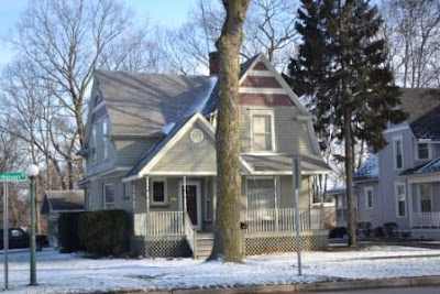


This home is considered a bungalow and was constructed in about 1925. It appears that Lyman and Eunice Butler were the first occupants of this house, though they had moved by the 1940s. The Butlers were married in 1924. The home was constructed soon after. Lyman Butler was the Marshall County Extension Agent for nearly twenty-five years until his death in 1947. The Butlers were living at this residence in the 1930 census but moved soon afterward to a home on Pearl Street in the south side of the city.

And that concludes our trip down North Michigan Street....but more to come from other parts of town including the south side.

15 February 2012

Plymouth: a main street like no other. Part 1

I assisted a group of architecture students and their professors in a design charrette in Plymouth. In their final report with the charrette they said that "Plymouth's main street was like no other, unparalleled in Northern Indiana." I think that they may have been correct. I intend to do a multi-part series on Plymouth's main street, which is named Michigan Street because it is the historic Michigan Road. I hope to highlight some of the best architecture of the street and give you the stories behind the elegant homes that line this graceful tree-lined Hoosier treasure.

The J. C. Capron House (above), constructed in 1900 in the Queen Anne style.
John C. Capron was born in Plymouth in 1871. He graduated from Stanford University in San Francisco in 1893 and started his law practice in 1895. J. C. Capron was captain of Company M, 157th Indiana Volunteers during the Spanish-American War. In 1894 he married Harriet Cullen of Plymouth. Capron was the Marshall County court stenographer for his father, Judge A. C. Capron, during the late 1890s. Capron lived in the home only a short time before it was sold to Clinton and Florence Bondurant. Clinton was born in German Twp., Marshall County, Indiana in 1870. He was engaged in the real estate and loan business and was county sheriff from 1900-1904. He married Florence Field in 1897. The Bondurants lived in the home with their daughters Helen and Dorotha in 1910 and 1920. The couple was still living at this address in 1930.


The former First United Methodist Church parsonage was constructed c. 1889 in a blend of Italianate and Gothic Revival styles. The original owner of the home is unknown but by 1910 it was being used as the parsonage for the United Methodist Church, which, at that time was located at the intersection of West LaPorte and South Center Streets. The congregation constructed a new building in 1914-1915 two blocks south of this home on the same side of Michigan Street. It was used as their parsonage until about 1951. The federal censuses and city directories reveal some of the ministers who had lived here; they include Ernest Wareing (1910), Otto Martin (1920), Robert Ross Shannon (1930), and Richard Blake (1949). Blake was living at the church’s next parsonage near the church in 1953.


In the days ahead we'll continue down the block-stay tuned!

27 November 2008

a Pilgrim & a Stranger

my Mayflower roots: Elder Brewster & Stephen Hopkins

Elder William Brewster (c. 1566 - April 10, 1644), was a Pilgrim colonist leader and preacher who came from Scrooby, in north Nottinghamshire and reached what became the Plymouth Colony in the Mayflower in 1620. He was accompanied by his wife, Mary Brewster, and his sons, Love Brewster and Wrestling Brewster. Son Jonathan joined the family in November 1621, arriving at Plymouth on the ship Fortune, and daughters Patience and Fear arrived in July 1623 aboard the Anne. Initially, the Pilgrams settled in Amsterdam, and worshipped with the Ancient Church of Francis Johsonson and Henry Ainsworth. Offput by the bickering between the two, though (which ultimately resulted in a division of the Church), the Pilgrams left Amsterdam and moved to Leiden, after only a year.


In Leiden, the group managed to make a living. Brewster taught English and later, in 1616-1619, printed and published religious books for sale in England though they were proscribed there, as the partner of one Thomas Brewer. In 1619, the printing type was seized by the authorities under pressure from the English ambassador Sir Dudley Carleton and Brewster's partner was arrested. Brewster escaped and, with the help of Robert Cushman, obtained a land patent from the London Virginia Company on behalf of himself and his colleagues.


In 1620 he joined the first group of Pilgrims aboard the Mayflower on the voyage to North America. When the colonists landed at Plymouth, Brewster became the senior elder of the colony, serving as its religious leader and as an advisor to Governor William Bradford. As the only university educated member of the colony, Brewster took the part of the colony's religious leader until a pastor, Ralph Smith, arrived in 1629. Thereafter, he continued to preach irregularly until his death in April 1644. Brewster was granted land amongst the islands of Boston Harbor, and four of the outer islands (Great Brewster, Little Brewster, Middle Brewster and Outer Brewster) now bear his name.


Stephen Hopkins (born about 1582 – 1644), was a tanner and merchant who was one of the passengers on the Mayflower in 1620, settling in Plymouth Colony. Hopkins was recruited by the Merchant Adventurers to provide governance for the colony as well as assist with the colony's ventures. He was a member of a group of passengers known to the Pilgrims as "The Strangers" since they were not part of the Pilgrim's religious congregation. Hopkins was one of forty-one signatories of the Mayflower Compact and was an assistant to the governor of the colony through 1636.


Hopkins had made a previous attempt to reach the New World in 1609 aboard the new flagship of the Virginia Company, the Sea Venture, on which Sir George Somers took the helm. Hopkins had embarked as a Minister's Clerk on the "Sea Venture", the Admiral of the Fleet. The ship was on the way to the Jamestown Colony in Virginia with much needed supplies when it was deliberately driven onto the reefs of Bermuda to prevent its foundering as a result of the damage it had sustained during a severe storm. All aboard, 150 passengers and crew and a dog, survived. The ship's longboat was fitted with a mast and sent to Virginia for help, but it and its crew were never seen again. Hopkins attempted to start a mutiny while stranded on the island. He was sentenced to death when this was discovered but was eventually set free after complaining of the "ruin of his wife and children". Hopkins and the remaining survivors spent nine months on Bermuda building two smaller ships, the Deliverance and Patience, from Bermuda cedar and materials salvaged from the Sea Venture. He and the other castaways eventually made their way to Jamestown, where Hopkins appears to have stayed for (some say) two years before returning to England. The Hopkins family is considered one of the First Families of Virginia. The story of the Sea Venture shipwreck (and Hopkins' mutiny) is said to be the inspiration for The Tempest by William Shakespeare.


Hopkins was respected for his previous experience with Indians and was elected ambassador for native relations. When Squanto arrived in Plymouth he resided with the Hopkins family. In 1621 Hopkins, Edward Winslow and William Bradford were delegated by their associates to treat with the Indians in the Plymouth vicinity on behalf of the Pilgrims and succeeded in winning the friendship of Chief Massasoit (1580-1661), concluding a peace treaty on 22 March 1621 in the Hopkins home. He later served in the Pequot War of 1637.

26 January 2011

Wards: the first cookie-cutter?

Wards Headquarters in Chicago


In 1996 I began work on a project that revealed a great deal about the emerging national economy based on chain department stores. The large, two and a half story, downtown building had been covered in sleek aluminum panels during the 1970s. Once the panels were removed and the gleaming white terra cotta facade was exposed, one certainly wondered why cover the building and do so much damage to the building?

But, it is what we Americans do to try to modernize and keep up with the Joneses (what is the plural of Jones?). So began the restoration saga of this building, aided by the original blueprints created for Montgomery Wards. The Wards corporation was begun by Aaron Montgomery Wards in 1872 as a catalog store, meaning you could order things through the catalog that you may view at local catalog outlets. But you couldn't buy those items on display.

1929 Wards Store in Plymouth

That all changed when one gentleman walked into a Wards catalog store in downtown Plymouth, Indiana in 1926. As the story goes, the man broke a tool and desperately needed to replace it immediately. He persuaded the manager of the catalog store to sell him the tool that day, and the rest, well, is history. The popularity made the Plymouth store the first retail store for Montgomery Wards, headquartered out of Chicago.

Restoring the Spirit of Progress

By 1928, only two years later, Wards had opened 244 stores. By 1929 that number had grown to 531-one of which was a new gleaming store in Plymouth opened just days before the stock market crash. Wards adopted a model for its many stores; these were largely constructed in white terra cotta, some with brown brick, and terra cotta details. A few things are dead give-aways of these stores, should you be on the hunt.

Wards Store Restored, 1997

Typically the stores have large upper story windows in either two or three bays; the window openings are curved in the upper corners. The stores also often had terra cotta urns of flowers on piers extending above the parapet. But the primary indicator, though not found on all Wards buildings, is the depiction of the "Spirit of Progress" and sometimes called the "Lady of Industry" that was inspired by the 1893 Chicago Exposition. In 1929 Wards had a large sculpture of the Spirit commissioned (17' tall) and placed on a four story tower it added to its Chicago headquarters on the Chicago River. Unfortunately the Plymouth store's Spirit had its top half broken off to add the modernizing metal panels. We were able to recreate the top perfectly.

A Wards Store in Texas


This all came back to me when my friend at Down the Road sent me a flicker page with a collection of Wards buildings around the country. It is fantastic to see so many in good condition and repurposed. Do you have one?

http://www.flickr.com/photos/army_arch/galleries/72157625743880475/


27 September 2011

Our Newest State Byway: The Historic Michigan Road and Our Inseparable Ties


This old historic road that runs through Indiana, like a spine connecting the Ohio River with Lake Michigan, the Michigan Road, and I are old friends. We have a history tied to every facet of my life and it seems to be a road I can’t get away from, a road that pulls me back with it into the past and pushes me along with it into the future.

I did all my growing up on “Michigan Road Lands”; tracts of land the State of Indiana received as part of a treaty with the American Indians and sold to settlers beginning in the 1830s. We lived on portions of my grandpa’s farm located just a mile off the Michigan Road. I went to church at the LaPaz Church of God, along the road, until I was about 6 years old when we drove the Michigan Road to South Bend every Sunday to attend a church less than a mile off the road. I went to LaPaz Elementary School, located on the road, through 6th grade. And then I completed Junior and Senior High School along the road at Grace Baptist in Plymouth. And I drove the road every day to get there. Then I went to college and drove the road every day to get to South Bend.

After I graduated from college and got a job in Plymouth, just a block off the Michigan Road, I moved into an apartment in the downtown and had one of the best views overlooking the Michigan Road at 120 ½ N. Michigan. And then I walked along the road to get to work. In 1997 I met my future wife at a coffee shop on the road and in 1998 we were married at the Church of the Brethren in Plymouth-you guessed it-on the road. And we took a celebratory drive in the backseat of her dad’s VW with the top down, down the Michigan Road. A few months later we moved into our first home at 308 South Michigan, a house constructed in 1853 when the road wasn’t much more than a dirt path.

When we purchased our second home it seemed that our new connection to the Michigan Road was going to be tenuous at best. We were located a full quarter mile off the road, again on Michigan Road Lands. But then I looked into the history of our house and the man who built it, Robert Schroeder. Schroeder came to Marshall County with his father in the early 1830s to build the Michigan Road. His father built a cabin on the east side of the road a few miles north of Plymouth. Robert purchased the property in 1865 and built his house at the east end of the property, which is our home now. His grave, marked “first settler of Marshall County” is located in the Fairmount Cemetery, the oldest cemetery in the county, just north of our home along the road. It seems we can’t get away from this old road. And now we travel it with our kids to school and church on Sundays.

As much as my life is and was connected to the road, it should be no surprise that my ancestors were just as connected. My Dad and my Grandma Crothers Hochstetler went to the old LaPaz School like I did. My grandparents established the Garner Inn in 1949 at the road’s intersection with Highway 6 south of LaPaz. They traded their farm near Tyner for the inn and lived above it. My Crothers ancestors’ farm was located on the east side of the road on the north side of LaPaz; they built their home in about 1860 and it is still there today. My Barnhill ancestors traveled the Michigan Road from Indianapolis to Argos and established their farm on the west side of the road just north of town in the 1840s. Great x4 grandpa Barnhill started the Antioch Church north of his home on the Michigan Road; his home is still there but the church is long gone. My great grandparents, named Bryant, traveled the road north from Rochester and lived in a home on the east side of Michigan north of Argos, also still there today. My great, great grandfather Garner had a saddle and tack shop on the north edge of downtown Rochester, on the west side of the road; the building is still there. My great grandmother Garner had a dress shop in downtown Argos, on the southwest corner of Michigan and Walnut Streets. My great, great, great grandfather Moore had a dry goods and general mercantile on Michigan Street in Argos; both buildings are still there. My ancestors are buried in the old Argos, Fairmont, and County Line Cemeteries in Marshall County. I say all this to demonstrate that my family did their living, dying, schooling, and worshipping along this great old road, dating back to almost its entire history.

I first learned about the history of the Michigan Road in 1997. I had always thought it was just the road to Michigan. While working with a group of people from Plymouth to put the downtown on the National Register of Historic Places, I learned about the road’s story. I learned that it was the very first road commissioned by the State of Indiana which began as an agreement in the 1826 treaty with the Potawatomie Indians. In 1829 the road was surveyed and construction started the following year. The road stretched 270 miles from Madison to Michigan City, connecting the new state capital, Indianapolis, with shipping ports. The road led to the establishment of a number of Indiana towns, particularly in the north where the land was solidly wilderness. The road was the path over which the American Indian was removed from their lands and also served as a path to freedom for escaping slaves. Between 2005 and 2007 I placed both downtown Rochester and Argos on the National Register where the Michigan Road serves as their main street.

The fascination with the Michigan Road grew as I traced the route on a state map and longed to drive the whole route. I got the chance when I won a bet with my wife over the amount of snow each of us predicted from a blizzard on New Year’s Day, 1999. The winner chose a location to take a weekend trip. I chose Madison by way of the Michigan Road. It was after that trip I realized there needed to be a way created to celebrate the rich history of the road. I submitted one grant request for funds to survey the historic sites along the road and was turned down. I sat down with the state historic preservation office to establish a method to do this under another application, but it didn’t fit neatly into their standards.

I wrote a blog post on the Historic Michigan Road in 2008 and a fellow named Jim Grey found me and left a message. He wrote a piece on the road, to which I commented that we should work together to find a way to honor the road. On August 2, 2008, two guys who had never met before scheduled a meeting to “discover” the Michigan Road in Fulton and Marshall Counties. At that time we talked about finding some way to promote the history of the road. Several weeks later I attended the Indiana Byways Conference on behalf of the Lincoln Highway and realized this was the answer, and contacted Jim with the idea.

We held a meeting in Rochester in January, 2009, and invited as many people we could think of who could be interested in this endeavor in the northern part of the state. It was decently attended by several people who would become our committee members. We decided to hold another meeting in Logansport later that spring and at that meeting we organized and began a series of community meetings up and down the Michigan Road into 2010. Communities showed great interest and support for the project. In December, 2010, we submitted a 90+ page document nominating the Historic Michigan Road as a state byway. In May, 2011 members of our committee presented our case to state officials and on September 9, 2011 an order by the Lt. Governor officially designated the Historic Michigan Road a state byway.

It seems that the road and I are inseparable, like old friends, and it looks like we’ll have a long and happy future together.

29 February 2020

Our Gold Star Memorial in Bronze: Pompeo Coppini, Sr.

Coppini's Bronze
In 1923, the American War Mothers of Marshall County began fundraising for a monument dedicated to the 29 individuals who died during World War I.  Their plans were announced in May of 1923, but included just 26 names.  An additional three names were added to the roster by the time it was inscribed and dedicated in 1925.  It was announced that ground was broken for the monument on September 11, 1924.  The site, at the east entry to Oakhill Cemetery off Oakhill Drive, was donated by Harrie Buck and A. B. Wickizer.  This part of the cemetery was originally called Buck Cemetery.

Marshall County's "Gold Star Memorial" 1925
Five names stand out among those 29, at least for historical reasons.  Hannah Burden was a nurse who died from Spanish Influenza while treating soldiers at a military camp, and is the only woman counted among the war dead.  Charles Reeve of Plymouth, Otho Place of Bremen, William Fleet of Culver, and James Corey of Argos each had their hometowns honor them with naming their respective American Legion Posts after them.

Dedication inscription on back of the monument
The  monument was officially called the "Gold Star Memorial" when it was dedicated on May 25, 1925.  It was described as tall piece of light marble (actually granite) surmounted by a cross bearing suitable inscription and a bronze tablet.  The 16' tall monument is surrounded by small marble crosses bearing the names of the dead, each fitted with a flag, and is flanked by drives splitting off the main drive on axis with the memorial.

The woman depicted represents the Motherland laying a laurel wreath
The man depicted represents a young American offering himself for the protection of the Motherland
After several years of attending Memorial Day services at the monument, I became more and more intrigued with the bronze tablet recessed into the face of the monument.  The bas-relief is an extraordinary cast, heavy in Art Deco influence, and is one of very few pieces of sculpture in the county.  The other day I examined the tablet closely and found the artist's signature in the bottom right corner:  P. Coppini Sr.

I'm not well-versed in sculptors of this period, or any period.  So I googled Mr. (Pompeo) Coppini (1870-1957), and found that he had an extraordinary career.  The Italian-born American immigrated in 1896 with just $40.  He lived in Texas most of his life where his greatest works are located.  His depictions of George Washington also gained fame and were placed in cities even outside of the United States.  A foundation and museum is named for him and it occupies his former studio in San Antonio.  Maybe his most famous work is "Spirit of Sacrifice" or the Alamo Cenotaph, a work commemorating the defenders of the Alamo.  He was also commissioned to design the Texas Centennial Half Dollar in 1934.  His work is also displayed on the grounds of the Texas State Capitol, Texas A & M, and the University of Texas.

"Spirit of Sacrifice" Alamo Cenotaph by Coppini
But Plymouth, Indiana?  How did the American War Mothers chapter find Coppini and commission him to create this impressive bronze?  This aspect of the story remains a mystery.  Coppini was in Chicago for a few years where he was a member of a Rotary Club.  He traveled to Fort Wayne and Decatur, Indiana in 1920 promoting the idea of public sculpture, particularly related to Fort Wayne's pioneers.  He spoke at Rotary clubs in both of these cities.  Could Plymouth have also been a stop for Coppini?  It is believed that we are home to the only Coppini sculpture in Indiana.  The Plymouth Republican carried an announcement a few days prior to Memorial Day that the memorial would be dedicated and gave this description of the bronze:  "...representing a young American offering himself for the protection of the motherland from whom he is receiving a wreath of laurel.  This is a reproduction of the work of Pompeo Coppini, a noted sculptor of Chicago."  The description of the bronze sounds like the words of the sculptor describing his work.  If there is an official name to the sculpture, it is not part of the newspaper's account.  Also noted is that the paper calls this a reproduction.
I reached out to the Coppini Museum in Texas, and did my own on-line searches.  And I came up with a twin (the only one I could find) to our memorial located in  Jones Park, a downtown square in the middle of Canton, Illinois (southwest of Peoria).  It was dedicated on Veterans Day 1922.  Mr. and Mrs. Ulysses Grant Orendorff presented the monument to the citizens of Canton in Fulton County, Illinois to commemorate those who died in World War I.  I believe that the couple commissioned Coppini for this work given this description provided "the bronze figure represents a young man, an American citizen, shielding with his own body the motherland, America, and she is bestowing upon him a wreath of laurel.  The young man is not in the uniform of a soldier as that would typify militarism which the donors of the gift especially desire not to do."  Fulton County, Illinois lost 110 men in the war.  The monument appears to still be at their park.

This photo is dated 1926, but it would accurately depict the scene of the Plymouth dedication a year prior, with Scouts and Vets standing side-by-side
The dedication of our monument had much fanfare on Memorial Day, May 25, 1925.  The unveiling was witnessed by a large crowd from all over Marshall County.  General Gignilliat, superintendent of Culver Military Academy, provided the main address.  The Academy's Black Horse Troop, military band, and a detachment of cadets with full presentation of colors and flags of the allies were present in a march that led to the monument.  Also in the convoy to the monument were the American War Mothers, in automobiles, Civil War Veterans (most in their 80s), Boy Scouts, and Camp Fire Girls.  This must have been quite a scene.  The ceremony was concluded with firing a salute and playing of taps.

Ode to a Truck

Wednesday, I took my travel companion on its last trip, from which it didn't come home with me. I took it for a drive the day before, to...